Holistic corridor
design with Hassell:
visualising trade-offs
How do we understand the impact of a new development, new park, or new transport? These projects can change the opportunities people have access to, the way transport systems work, the type of economic activities in a neighbourhood, and other city systems.
While it is commendable to state that a project wants to improve all the things, the reality is that projects will need to balance competing objectives. Constraints in project budgets, physical context, and community needs all shape the design of projects. Holding all these factors in one’s head becomes impossible. That’s where we come in. Our technology links together complex questions, so we can understand what happens when our cities change.
Analysing who has access to new projects does not have to be a post-design exercise.
Visualising design decisions for green and blue infrastructure projects
Let’s look at this multi-system consequence concept in action. We partnered with Hassell to bring data to their latest research on the benefits and trade-offs of corridor design. Hassell’s complete report on corridors will be published later in the year. In this post, we reference key insights from the research.
Hassell’s study identifies corridors as significant linear spaces that have the power to either connect or divide communities, environments and economic activity. Their research shows how built and natural corridors can create a range of benefits by “facilitating the movement of people, plants, wildlife, goods and resources between different nodes of activities”. But the research also finds significant conflicts arising between different uses, objectives, and stakeholders. As Camilla Siggaard Andersen, the report’s research lead, surmises:
“Corridor design is always a matter of weighing up competing objectives.
Our report presents the key considerations for this negotiation, but it has also become clear that there’s really no ‘one size fits all’ design.”
Diagonal worked with Hassell to explore, how digital
tools might be used to weigh up competing objectives.
As one aspect within Hassell's wider study, we focused
on one corridor as a case study.
We selected the Ecoducto Río de la Piedad, in Mexico
City. This case study allows us to illustrate how
quantitative analysis can be used to contextualise
qualitative design decisions.
The Ecoducto is a raised greenway and water
purification system that spans 1.6km along and above
the Viaducto Miguel Alemán freeway. The linear space
was originally a river (Rio la Piedad), which had been
encased beneath the six-lane highway and made
inaccessible to the surrounding community. Through
citizen activism, the potential of this corridor was
raised, and in 2018 the Ecoducto park opened. The
project was “a
citizen-led project developed to raise awareness about
water issues."
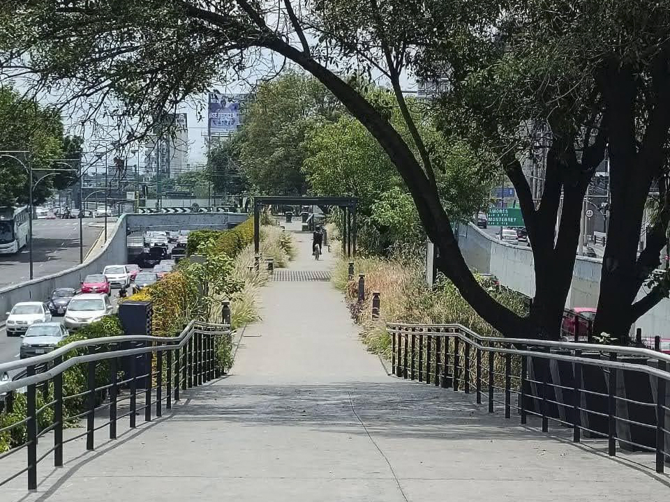
Ecoducto. Photo credit: Regina Ferrari and Fernando Camacho
The Ecoducto includes a waste water purification system. It treats the residual black water from the river that is buried under the freeway for irrigation in the park. It also acts as a wetlands ecosystem, a walking and cycling route, and hosts a museum of water plants.
Still, access to the Ecoducto is constrained by the Viaducto Miguel Alemán highway, which surrounds it on either side. In Hassell’s study, the Ecoducto is identified as an example of a corridor that’s both successfully serving multiple functions and showcasing ongoing negotiations between movement, place, and - most importantly - access.
The Ecoducto was therefore interesting as a case study to test design optimisation tools across competing objectives.
Defining an optimisation problem
Diagonal defined three realistic, but unofficial, objectives of the project:
- Cost: make the structural design affordable
- Access: make the Ecoducto accessible to people in the local area
- Proximity: ensure access gates are close to public transit hubs (metro stations)
Diagonal also defined some realistic, but unofficial, constraints of the project. We identified possible access gates to the Ecoducto. Every place where the existing road and pedestrian network leads to the Ecoducto is a potential access gate. We considered it undesirable to build access gates right next to each other. As a constraint, we removed the option of incorporating adjacent access gates into a design option.
We also made an assumption that gates should be relatively evenly spaced. We wouldn’t want all of the gates to be clustered on one side of the corridor. So we inserted a requirement that there should be a minimum of 4 gates, distributed across 4 segments of the Ecoducto.
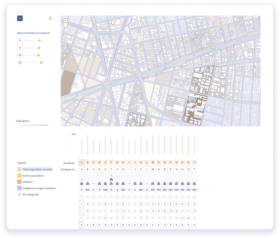
We approached finding the balance between these three objectives and constraints as an optimisation problem. We analysed population demographic data, transport data, and the physical form of the Ecoducto.
We focused on an early design decision that scopes these three objectives: where should the entrances into the corridor be located?
We then experimented with different scenarios that reflect different prioritisations of our three objectives. For example, what happens if cost drives the project design? Or, what happens if access to the local population drives project design? What are the consequences on our objectives? With only these three, illustrative, objectives we identified 18 different, ‘near optimum’ Ecoducto design 'solutions'. Each solution reflects a different possible option for Mexico City and provides benefits across each of our objectives. Next, we dive into the detail behind how we structured our optimisation approach.
Building an optimisation model
To explore the trade-offs of different design scenarios, we made high-level assumptions about our three objectives:
- cost
- access to local people
- proximity to transport (metro stops)
We applied example weightings to each, in order to illustrate the feedback between prioritising objectives, project designs, and project outcomes. If you want to skip to the results - scroll down to the next section.
Cost
Because the Ecoducto is located in the median of a highway, building access gates to the Ecoducto may drive the cost of the project. Accessing the greenway can be achieved in three different ways. The first way to access the Ecoducto is by using existing intersections between the freeway median and the road network.
Existing intersection between Ecoducto and pedestrian
crossing.
Photo credit: Regina Ferrari and Fernando Camacho
The second way to access the Ecoducto could be through extending existing pedestrian bridges that cross over the highway, but do not connect to the median.
The third option to access the Ecoducto could be through building new pedestrian or cycle bridges over the highway and connecting them to the median.
We made assumptions about the capital cost of building different access gates into the Ecoducto. Building access gates might also have environmental costs, like disrupting the green corridor or reducing space for water collection facilities. We did not directly factor these costs into our analysis - but you could!
We assumed that using existing intersections between the freeway median and road network would be a lowest-cost option to access the Ecoducto. Building new, active travel bridges as access points would be the most expensive option.
Accessibility
Access to the Ecoducto is restricted by the surrounding highway. The number of people who can readily access the Ecoducto is therefore linked to the number and location of access gates. As described in the cost section (above) adding more access gates could drive up the cost of building the Ecoducto. The location of gates has a clear trade-off: construction costs vs. the number of people who can reach the Ecoducto.
In our optimisation model, we looked for possible gate locations compared with how many people the gate served. We used census data to bring in population figures. We assumed people could “access” the Ecoducto if they lived within 500m of a potential gate. We were able to drill into population demographics to understand what communities might be served by the Ecoducto, depending on which gates were built.
For example, we looked at how gate selection varied access for an older population (over 64 years old), a younger population ( under 15 years old), and people who speak an indigenous language.
Proximity to public transport hubs
In addition to cost and local access considerations, we prioritised access to metro stations. We were able to understand how building gates that were positioned close to metro stations could impact cost and local access.
All together
We used an optimisation model to understand early-stage design decisions on long-term consequences. Analysing who has access to a corridor does not have to be a post-design exercise. Our model balanced input constraints (cost drivers) and outcomes (local access and proximity to metro stations) to automatically suggest multiple design scenarios.
Conclusions & next steps
Optimisation has traditionally been a costly and slow process. As a consequence, few architects and engineers use optimisation analysis in the scoping and discovery phases of a project. But the opportunity to analyse complex, multi-system consequences as part of the design process can build stronger cases for bolder projects. Our analysis is powered by our own data model and analysis engine, which enables us to compute information about different scenarios, fast.
In the case of developing a green corridor, there may be a tension between maximising the number of people who can access the green space by creating many entrances to the corridor vs. limiting the number of traffic disruption points. Or you might have other objectives, like maximising green landscaping by limiting entrances that would interrupt an ecological corridor.
To make sense of all these competing priorities and constraints, we make the consequences tangible. We bring evidence and visualisations to early design discussions.
Ultimately, design decisions need to be made by people. With evidence that describes the context, and illustrating the outcomes of different scenarios - we give designers better tools to achieve more equitable, sustainable, and cost effective outcomes.
"It's been really interesting to work with Diagonal to understand how digital tools could help negotiate trade-offs in the corridor design process. With so many parameters to consider, and so many stakeholders to involve, a solid evidence base for decision-making is crucial." Camilla Siggaard Anderson, Hassell
This case study used a linear optimisation approach to compare possible outcomes. But our technology is designed for even more complex analysis methods. As follow-on work, we could apply a non-linear optimisation to understand the consequences of even more moving pieces - which would reflect a wider range of design options.
Let’s work together
Do you want to understand the multi-dimensional consequences of your next project? We want to work with you.
best viewed on desktop

